

- This topic is empty.
-
AuthorPosts
-
16/10/2026 at 16:17 #12930
Underwater infrastructure plays a vital role in modern cities, industrial facilities, and environmental management systems. However, inspecting assets located beneath rivers, lakes, reservoirs, ports, and drainage networks can be challenging. Limited visibility, changing water depths, suspended sediment, strong currents, and hidden obstacles often prevent engineers from obtaining accurate information through conventional visual inspection alone.
To overcome these difficulties, sonar detection has become an important solution for underwater surveying and infrastructure assessment. By transmitting sound waves through water and analyzing the returning signals, sonar systems can identify submerged objects, measure underwater depths, map terrain, and reveal potential infrastructure problems. This technology provides valuable information for municipal engineering, environmental research, construction planning, and long-term asset maintenance.
For engineering contractors, municipal authorities, and infrastructure operators, understanding how sonar detection works and where it can be applied is essential for improving inspection accuracy, controlling project costs, and reducing operational risks.
Understanding Sonar Detection Technology
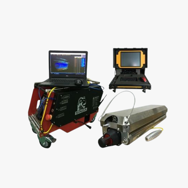
Sonar, short for Sound Navigation and Ranging, is an acoustic sensing technology used to investigate underwater environments. A sonar device sends sound pulses into the water and records the echoes reflected by the seabed, submerged structures, or other objects. Specialized software then processes these signals to generate measurements, images, or three-dimensional representations of underwater conditions.
Different surveying tasks require different sonar systems. Common equipment includes:
-
Side-scan sonar: Produces detailed images of objects and surface features across the underwater terrain.
-
Multibeam sonar: Collects depth measurements across a wide area to create detailed bathymetric maps.
-
Single-beam echo sounders: Measure water depth along a survey line.
-
Imaging sonar: Generates acoustic images of submerged objects, especially where visibility is poor.
-
Sub-bottom profilers: Investigate sediment layers and geological features beneath the waterbed.
Selecting the appropriate equipment depends on the survey area, required resolution, water conditions, and intended use of the collected data.
Unlike inspection methods that depend primarily on divers or underwater cameras, sonar can survey large areas efficiently and operate in environments where visibility is severely restricted. When properly planned and interpreted, it provides a safer and more systematic way to understand underwater conditions.
1. Underwater Terrain Mapping for Rivers and Lakes
Riverbeds and lake bottoms are constantly affected by erosion, sediment transport, water flow, and seasonal changes. These processes can alter underwater topography and create unexpected challenges for construction and maintenance projects.
Sonar detection enables survey teams to collect accurate depth measurements and develop detailed maps of underwater terrain. The resulting information can help engineers identify:
-
Changes in water depth and bottom elevation
-
Areas affected by sediment accumulation
-
Scour around bridge piers and other structures
-
Steep underwater slopes and depressions
-
Potential hazards affecting navigation
-
Changes in riverbed or lakebed morphology
Such data is particularly valuable before dredging, bridge construction, water intake installation, and other engineering activities. By understanding existing underwater conditions, project teams can improve design accuracy, estimate construction requirements, and reduce the likelihood of unexpected problems during implementation.
2. Inspecting Municipal Drainage Infrastructure
As urban areas expand, drainage networks become more extensive and increasingly difficult to maintain. Large stormwater conduits, culverts, discharge channels, retention facilities, and other water conveyance structures may contain substantial amounts of water, making conventional visual inspection less effective.
Sonar-based inspection offers an alternative for investigating accessible submerged sections of drainage infrastructure without requiring extensive excavation or unnecessary interruption to surrounding services.
Typical inspection applications include:
-
Large stormwater drainage pipes
-
Submerged outfalls and discharge structures
-
Retention ponds and detention basins
-
Flood management channels
-
Water conveyance structures with limited visibility
By identifying sediment deposits, obstructions, and changes in internal geometry, sonar surveys can help maintenance teams determine where further investigation or cleaning is necessary.
Early detection also allows municipalities to prioritize maintenance activities according to actual site conditions rather than relying exclusively on routine schedules. This approach can improve drainage performance and reduce the risk of localized flooding or unexpected infrastructure failures.
The appropriate inspection method should be selected according to pipe dimensions, water depth, accessibility, and the type of defect being investigated. Sonar is especially useful for submerged areas that cannot be adequately assessed through conventional CCTV inspection alone.
3. Assessing Underwater Pipelines and Submerged Utilities
Pipelines frequently cross rivers, lakes, reservoirs, and coastal environments to transport water, wastewater, and other industrial fluids. Although many of these installations are designed for long-term service, their underwater sections remain exposed to changing environmental conditions.
Potential risks include erosion around pipe supports, sediment movement, anchor strikes, vessel-related damage, and displacement caused by changes in the surrounding ground.
Sonar detection helps engineers examine the underwater environment surrounding these pipelines. Depending on the equipment and survey configuration, inspections may reveal pipe exposure, changes in alignment, unsupported sections, nearby debris, and possible signs of scour.
The information can support several important maintenance decisions:
-
Determining whether additional structural inspection is necessary
-
Identifying areas requiring closer investigation
-
Evaluating changes in underwater pipeline positioning
-
Planning maintenance or protective measures
-
Establishing baseline data for future monitoring
Sonar does not replace every form of pipeline testing. Internal leakage, wall thickness loss, and certain material defects may require other inspection technologies. However, when combined with appropriate testing methods, sonar provides valuable external condition information and helps develop a more comprehensive understanding of submerged pipeline assets.
4. Improving Planning for Trenchless Pipeline Rehabilitation
Trenchless rehabilitation techniques are widely used to repair aging underground pipelines while limiting excavation, traffic disruption, and disturbance to nearby properties. However, successful rehabilitation depends on reliable information about existing infrastructure and site conditions.
When a project involves submerged pipeline sections or underwater access points, sonar detection can contribute useful survey data before construction begins.
Its potential applications include:
-
Identifying submerged pipeline sections and visible alignment features
-
Measuring underwater distances and elevations
-
Locating obstacles near the proposed work area
-
Assessing surrounding sediment conditions
-
Supporting access planning and construction preparation
These findings help contractors identify potential constraints and determine whether supplementary inspection is required before selecting a rehabilitation method.
For projects involving complex drainage networks or submerged utilities, combining sonar surveys with pipeline CCTV inspection, QV inspection, and other engineering assessments can reduce uncertainty during project planning.
Professional sonar detection services can therefore play an important role in gathering underwater information, improving construction preparation, and supporting more informed engineering decisions.
5. Monitoring Bridge Foundations and Scour Conditions
Bridge foundations are frequently located beneath the water surface, where direct observation is difficult. One of the major concerns for bridge owners is scour, a process in which flowing water removes sediment around foundations and support structures.
If scour progresses without detection, it may reduce foundation support and compromise structural safety.
Sonar surveys provide a practical way to examine underwater conditions around bridge piers and abutments. Depending on the survey system, engineers may use the collected data to:
-
Measure the depth and extent of scour holes
-
Identify exposed foundation components
-
Locate debris accumulating around bridge supports
-
Compare underwater terrain across different inspection periods
-
Develop bathymetric maps or three-dimensional models
Repeated surveys can help bridge managers monitor changes and identify areas requiring more detailed structural assessment.
Sonar findings should be interpreted alongside hydrological information, structural records, and relevant engineering standards. When incorporated into a comprehensive inspection program, they provide important evidence for bridge maintenance planning and risk management.
6. Maintaining Harbors, Ports, and Navigation Channels
Ports and harbors operate in dynamic underwater environments. Vessel movements, sediment transport, anchoring activities, and construction work can all change seabed conditions or introduce hazards into navigation areas.
Reliable underwater information is essential for maintaining safe shipping routes and supporting efficient port operations.
Sonar detection can help port operators locate submerged objects, investigate damaged structures, identify sediment accumulation, and assess underwater features around quay walls and other facilities.
Common applications include:
-
Detecting sunken equipment and lost anchors
-
Identifying underwater obstructions
-
Mapping sediment deposits in navigation channels
-
Assessing seabed conditions near port structures
-
Supporting dredging surveys and post-dredging verification
Accurate bathymetric measurements help engineers determine where sediment removal is necessary and estimate the extent of dredging work. Side-scan sonar can complement depth measurements by revealing objects or surface features that may not be adequately characterized by bathymetric data alone.
By combining appropriate sonar systems with regular monitoring, port authorities can improve navigation safety, manage maintenance budgets, and reduce disruptions to maritime operations.
7. Supporting Environmental Research and Aquatic Monitoring
Understanding underwater terrain and sediment movement is important for protecting aquatic ecosystems and managing water resources. Environmental conditions can change gradually or rapidly because of erosion, flooding, construction activities, and changes in water flow.
Sonar detection allows researchers and environmental agencies to investigate underwater features across relatively large areas without depending entirely on direct visual observation.
Potential applications include:
-
Mapping submerged aquatic habitats
-
Studying riverbed changes and erosion patterns
-
Monitoring sediment transport
-
Surveying wetlands and shallow-water environments
-
Supporting reservoir management
-
Establishing baseline information for environmental assessments
Because sonar relies on acoustic signals, it can operate in turbid water where conventional optical methods may provide limited information. Nevertheless, sonar data does not automatically identify every biological or chemical condition. Additional sampling, water quality testing, or ecological surveys may be required to evaluate the broader environmental situation.
When used as part of an integrated monitoring program, sonar contributes valuable spatial information that supports evidence-based environmental management and sustainable water resource planning.
8. Locating Submerged Objects for Search and Recovery
Recovering objects from underwater environments can be difficult when visibility is poor or the search area is extensive. Manual diving searches may require considerable time and can expose personnel to unnecessary hazards if underwater conditions are not well understood.
Sonar provides a useful preliminary search method by scanning underwater areas and detecting acoustic reflections associated with submerged objects.
Potential targets include:
-
Lost construction machinery
-
Submerged vehicles
-
Anchors and metal equipment
-
Large pipes and structural components
-
Sunken debris
-
Other substantial objects on or near the seabed
Side-scan sonar can help locate objects across broad survey areas, while imaging sonar may provide additional details about selected targets. Once an object has been detected, its location can be recorded for follow-up inspection or recovery planning.
The success of a search depends on factors such as target size, material, orientation, bottom composition, and survey resolution. Smaller objects or items buried in sediment may require specialized equipment or supplementary investigation.
By narrowing the search area and providing preliminary target information, sonar can improve recovery planning and reduce dependence on extensive manual searches.
9. Integrating Sonar Survey Results with GIS Systems
Geographic Information Systems (GIS) have become important tools for organizing infrastructure data, planning maintenance activities, and supporting municipal asset management.
Sonar surveys generate spatial information that can be incorporated into GIS platforms when suitable positioning, coordinate references, and data-processing procedures are used.
Once integrated with other infrastructure records, sonar-derived information can help organizations:
-
Maintain digital records of underwater assets
-
Compare survey results collected at different times
-
Identify locations requiring maintenance
-
Improve infrastructure planning and budgeting
-
Support emergency response and risk assessment
-
Coordinate underwater information with underground utility networks
For example, a municipality may combine sonar survey results with drainage network maps, pipeline inspection records, and maintenance histories. This integrated database provides a more complete picture of asset conditions and helps decision-makers establish maintenance priorities.
Reliable GIS integration depends on accurate positioning, consistent data formats, and appropriate quality control. When these requirements are met, sonar information becomes a valuable component of long-term infrastructure management.
Jiangsu Zhenqi Construction Engineering Co., Ltd.: Integrated Infrastructure Inspection Solutions
Jiangsu Zhenqi Construction Engineering Co., Ltd. is a high-tech enterprise specializing in municipal engineering and underground infrastructure services. Its service portfolio covers trenchless pipeline rehabilitation, pipeline CCTV inspection, QV pipeline inspection, municipal drainage maintenance, pipeline dredging, underwater operations, rainwater and wastewater investigation, zero-discharge wastewater investigation, and GIS construction.
The company has introduced construction technologies and equipment from Europe and the United States while developing a team of technical professionals to support its engineering activities. Through standardized operating procedures, qualified personnel, and a customer-focused service approach, the company serves municipal authorities, engineering contractors, and infrastructure owners seeking practical inspection and maintenance solutions.
For projects involving submerged assets and complex drainage networks, combining sonar detection with complementary inspection and infrastructure management services can help establish a clearer understanding of site conditions. Such an approach supports better maintenance planning, more efficient project execution, and improved management of urban underground utility networks.
The appropriate survey scope and equipment should always be determined according to actual site conditions and the client's technical requirements.
en.zhenqijianshe.com
Jiangsu Zhenqi Construction Engineering Co., Ltd. -
-
AuthorPosts

- You must be logged in to reply to this topic.